General aviation continues to be a segment where safety remains a significant challenge.
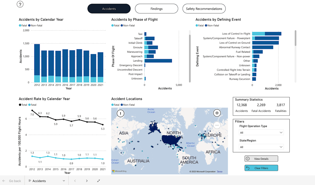
The National Transportation Safety Board (NTSB) created an interactive dashboard showing 12,368 accidents between 2012 and 2021. Of them, 2,269 were fatal, leading to 3,817 deaths.
Navigation
We looked into accidents related to navigation using these filters:
- Flight planning/navigation – 85 accidents
- Geographic disorientation (lost) – 13 accidents
- Navigation error – 9 accidents
Many of them were caused by geographic disorientation (i.e., getting lost), resulting in fuel starvation or flight into treacherous terrain. When pilots got disoriented, they often ended up in areas their aircraft couldn’t handle, like turning into the wrong valley and not being able to turn or climb over rising terrain. Or they couldn’t locate the necessary airfield and eventually ran out of fuel, which led to emergency landings or crashes. It can be reasonably assumed that for every accident we know about, numerous near-misses happen but don’t get reported.
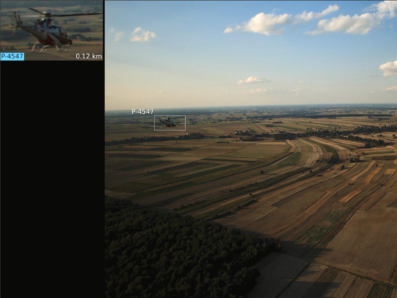
A simple, robust position signal may have been enough to prevent most of these from occurring. Daedalean’s Visual Positioning System (VPS) offers GNSS-independent navigation to improve situational awareness and safety.
Selected Reports
Accident Number: CEN13LA293
Aircraft: AIR TRACTOR INC AT-602
Date & Time: May 23, 2013, 18:15 Local
Excerpt from the report: “The pilot planned to spray a field and then refuel. After spraying the field, the pilot circled for about 15 minutes looking for his intended airport, but he could not locate it. He spotted another airport about 5 miles south of his location and headed in that direction.”
“…the engine experienced a total loss of power. The pilot made an emergency landing in a field about 1 mile southeast of the airport. After the accident, he reported that he had exhausted the airplane’s fuel supply. Examination of the wreckage revealed no evidence of usable fuel in the fuel tanks…”
Probable cause of accident: “Contributing to the accident was the pilot’s inadequate preflight planning, which precluded him from locating his intended destination and led to fuel exhaustion.”
Accident Number: GAA15CA091
Aircraft: LEFEVER PAUL M RV12
Date & Time: May 23, 2015, 13:00 Local
Excerpt from report: “[the pilot] reported that he was unable to manipulate the fuel station pumps where he had landed, so he decided to fly to another airfield that was about 20 miles away.
The pilot wrote that somehow he did not make the right turn and became “lost”. After noticing that his fuel level was low, he decided to make an off airport precautionary landing. The pilot reported that during the landing, the airplane’s nose wheel caught “heavy grass” and nosed over sustaining substantial damage to the fuselage and both wings.”
Probable cause of accident: “The pilot’s selection of unsuitable terrain for a precautionary landing, which resulted in a nose over.”
Accident Number: GAA15CA153
Aircraft: GRUMMAN AMERICAN AVN. CORP. AA 5A
Date & Time: July 1, 2015, 08:30 Local
Excerpt from report: “During the second leg of a solo cross country flight, the student pilot reported that he became disoriented in mountainous terrain, and flew down a valley that he thought would lead him to his planned route. After entering the valley, the student pilot did not believe he had sufficient distance laterally to turn around, so he decided to initiate a climb to clear the ridge line in front of him. During the climb he heard the stall warning horn intermittently and realized he could not clear the ridge line ahead. The student pilot made an emergency landing into the rising terrain ahead of him and came to rest in the trees.”
Probable cause of accident: “The student pilot’s disorientation in mountainous terrain and course deviation into a canyon, which resulted in the airplane’s inability to out climb terrain and a forced landing.”
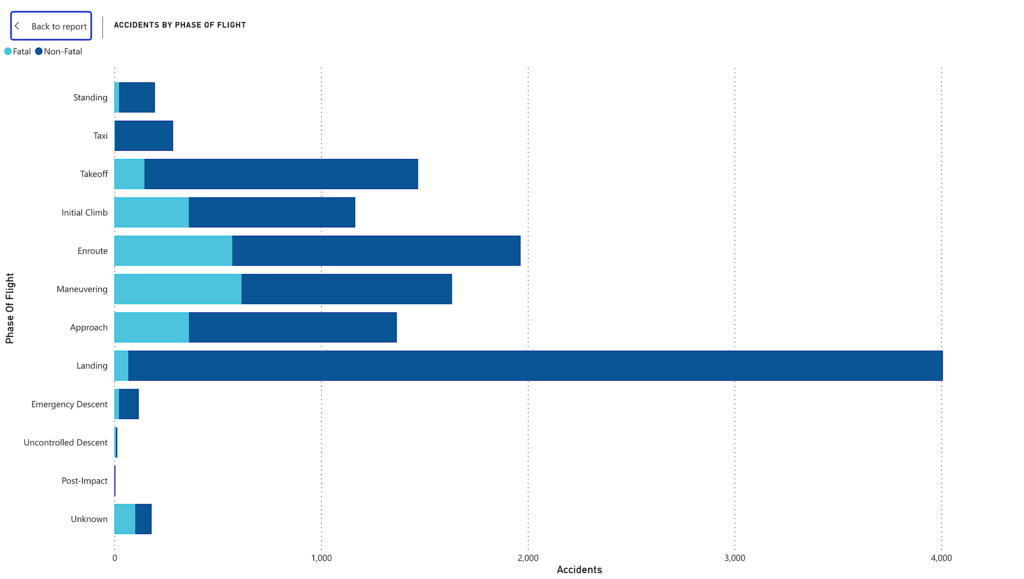
Landing
The following plot from the NTSB dashboard shows that landing is the phase of flight with the most accidents during the 2012-2021 period.
We found many reports of accidents that could have been reduced in severity or prevented with a landing guidance instrument, e.g., cases where the inability to locate the needed runway or stay on the right glideslope led to planes hitting trees or the ground. Daedalean’s Visual Landing System (VLS) provides continuous visual guidance for both emergency and planned landings, so it helps pilots to find the nearest airfield and correctly identify the runway, and then leads them to safe landing down to the ground.
Selected Reports
Accident Number: GAA16LA135
Aircraft: PINKSTON RANDY T RV-7
Date & Time: February 18, 2016, 18:15 Local
Excerpt from report: “…the pilot, who stated that the landing was his first one at the residential airpark and that he thought that the side road was the runway. The pilot reported that there were no mechanical or weather issues as he was attempting to land. The airplane struck three mailboxes, a basketball hoop, phone lines, and a car and then came to rest inverted.”
Probable cause of accident: “The pilot’s misidentification of a parallel roadway for the runway and the airplane’s subsequent collision with numerous objects during landing.”
Accident Number: GAA18CA069
Aircraft: WEAVER DAVID A PULSAR 912XP
Date & Time: December 2, 2017, 16:50 Local
Excerpt from report: “The pilot reported that, while making a straight-in approach to a private airport just after dusk, but before dark, he attempted to activate the pilot-controlled lighting (PCL) but was unsuccessful. He added that he continued toward the airport, and while maneuvering for landing, he lost sight of the airport. The pilot did not regain visual reference of the airport during the landing descent, and the airplane impacted a fence adjacent to the runway.”
Probable cause of accident: “The pilot’s decision to continue to land without visual reference to the airport in low light conditions.”
Accident Number: CEN21LA182
Aircraft: Cessna 180
Date & Time: April 2, 2021, 12:35 Local
Excerpt from report: “..the pilot reported that he had not landed on his intended runway but on an unimproved dirt road about 0.3 miles from the runway that ran parallel to the runway. The pilot reported that he had spent too much time looking for traffic in the landing pattern and lost situational awareness of his position relative to the runway.”
Probable cause of accident: “The pilot’s loss of situational awareness, and his unintended landing on a soft unimproved dirt road…”
Flight at Night
Geographic disorientation, in particular, was commonly reported during night VFR flights. Just like in the daytime, pilots sometimes ran out of fuel and had to make emergency landings. However, in low-light situations, pilots were more likely to crash into the ground because they couldn’t see impending obstacles. These accidents usually happened in sparsely-populated areas with not much ground lighting.
Currently, Daedalean’s VPS and VLS are based on visual input from camera sensors and are limited by the daytime VMC. Now, we are adding sensors beyond the optical spectrum (infrared, radar) and other information sources to expand operations during nighttime, in degraded visual conditions, and under instrument flight rules.
Accident Number: CEN16LA242
Aircraft: CZECH AIRCRAFT WORKS SPOL SRO SPORTCRUISER
Date & Time: July 1, 2016, 22:06 Local
Excerpt from report: “The pilot reported that he was unable to locate the destination airport because it was dark. The airplane was low on fuel, so he decided to land the airplane on an interstate highway. During the landing roll, the airplane’s right wing hit a wire road divider post, which resulted in substantial damage to the airplane.”
Probable cause of accident: “The pilot’s inadequate flight planning and navigation for a flight at night…”
Accident Number: CEN18LA014
Aircraft: DIAMOND AIRCRAFT IND INC DA 40
Date & Time: October 16, 2017, 21:12 Local
Excerpt from report: “The pilot reported that he became disoriented as he orbited the airport waiting for the airport manager to turn on the runway lights, which resulted in him believing that he was on final approach to runway 1 instead of runway 19. The pilot stated that, during final approach, he incorrectly identified a crossing road that he believed was about 3/4 mile south of the runway 1 approach threshold; however, the road he observed was about 1 mile north of the airport. The pilot stated that he and his passenger suddenly saw tree branches appear as the airplane descended on final approach.”
Probable cause of accident: “The pilot’s geographic disorientation while maneuvering in the airport traffic pattern in dark night conditions…”
Accident Number: CEN19CA017
Aircraft: Piper PA28R
Date & Time: October 27, 2018, 19:40 Local
Excerpt from report: “The pilot reported that he entered a left traffic pattern for runway 30 during night, visual meteorological conditions. Although the pilot thought he had sufficient altitude during the initial phase of the final approach based on his altimeter indication, shortly after turning to final approach, the airplane impacted terrain.”
Probable cause of accident: “The pilot’s incorrect altimeter setting during the night visual approach, which resulted in a controlled flight into terrain.”
Conclusion
The accidents listed on the NTSB website represent just a fraction of aviation incidents that occur globally. Still, we found numerous accidents that could have potentially been prevented with a redundant positioning source and/or landing guidance. Robust and reliable navigation can help avoid these situations or enable a pilot to return to the planned route safely.
These reports also highlight that during approaches and landings, especially on unpaved surfaces, pilots may struggle to identify their destination airstrip, contributing to increased stress during a critical flight phase. Landing guidance during the final approach can further enhance safety for pilots by ensuring an optimal glideslope. Finally, the NTSB data confirms the importance of preventing disorientation and providing terrain avoidance for safe night flying.
This article was originally published by Daedalean.